


Pertiys Les vignes

Louis-Christian
Gebruiker
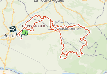

Lengte
30 km

Max. hoogte
416 m

Positief hoogteverschil
638 m
Km-Effort
39 km

Min. hoogte
218 m

Negatief hoogteverschil
656 m
Boucle
Neen
Datum van aanmaak :
2021-11-07 07:47:47.631
Laatste wijziging :
2021-11-07 11:16:07.289
3h27
Moeilijkheid : Medium

Gratisgps-wandelapplicatie
 SityTrail
IGN / Geografische instituten
SityTrail Plus
De wereld gaat voor u open
Over ons
Tocht Mountainbike van 30 km beschikbaar op Provence-Alpes-Côte d'Azur, Vaucluse, Pertuis. Deze tocht wordt voorgesteld door Louis-Christian.
Plaatsbepaling
Land:
France
Regio :
Provence-Alpes-Côte d'Azur
Departement/Provincie :
Vaucluse
Gemeente :
Pertuis
Locatie:
Unknown
Vertrek:(Dec)
Vertrek:(UTM)
702725 ; 4840741 (31T) N.
Opmerkingen