


Parc de Sceaux

jlrayon
Gebruiker
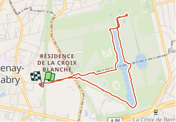

Lengte
5,2 km

Max. hoogte
88 m

Positief hoogteverschil
70 m
Km-Effort
6,1 km

Min. hoogte
53 m

Negatief hoogteverschil
70 m
Boucle
Ja
Datum van aanmaak :
2021-11-20 10:05:25.674
Laatste wijziging :
2021-11-20 12:24:56.771
2h18
Moeilijkheid : Gemakkelijk

Gratisgps-wandelapplicatie
 SityTrail
IGN / Geografische instituten
SityTrail Plus
De wereld gaat voor u open
Over ons
Tocht Stappen van 5,2 km beschikbaar op Île-de-France, Hauts-de-Seine, Châtenay-Malabry. Deze tocht wordt voorgesteld door jlrayon.
Plaatsbepaling
Land:
France
Regio :
Île-de-France
Departement/Provincie :
Hauts-de-Seine
Gemeente :
Châtenay-Malabry
Locatie:
Unknown
Vertrek:(Dec)
Vertrek:(UTM)
447441 ; 5401623 (31U) N.
Opmerkingen