


libin

Airelle
Gebruiker
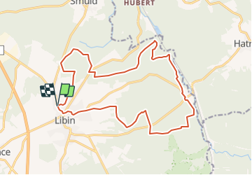

Lengte
18,2 km

Max. hoogte
509 m

Positief hoogteverschil
445 m
Km-Effort
24 km

Min. hoogte
361 m

Negatief hoogteverschil
444 m
Boucle
Ja
Datum van aanmaak :
2021-11-20 17:04:12.022
Laatste wijziging :
2021-11-21 09:09:11.165
5h29
Moeilijkheid : Zeer moeilijk

Gratisgps-wandelapplicatie
 SityTrail
IGN / Geografische instituten
SityTrail Plus
De wereld gaat voor u open
Over ons
Tocht Stappen van 18,2 km beschikbaar op Wallonië, Luxemburg, Libin. Deze tocht wordt voorgesteld door Airelle.
Plaatsbepaling
Land:
Belgium
Regio :
Wallonië
Departement/Provincie :
Luxemburg
Gemeente :
Libin
Locatie:
Unknown
Vertrek:(Dec)
Vertrek:(UTM)
661524 ; 5539443 (31U) N.
Opmerkingen