Tocht Mountainbike Virton - Bois de la Côte II  -  Balade_VTT_23kms - Photo

Bois de la Côte II - Balade_VTT_23kms

 Pascal L
Pascal L

Gebruiker

© OpenStreetMap contributors
Lengte
Lengte
23 km
Max. hoogte
Max. hoogte
404 m
Positief hoogteverschil
348 m
Km-Effort
Km-Effort  
28 km
Min. hoogte
Min. hoogte
200 m
Negatief hoogteverschil
348 m
Boucle
Boucle
Ja
Datum van aanmaak :
2021-11-23 10:52:52.359
Laatste wijziging :
2022-11-05 15:59:44.098

(0 Bericht)

Mountainbike
Mountainbike
2h00
Moeilijkheid : Medium

Scan deze QR-code om de tocht te openen in de SityTrail-applicatie

Gratisgps-wandelapplicatie

Logo SityTrail SityTrail

IGN / Geografische instituten

SityTrail uit de App Store downloaden SityTrail uit Google Play downloaden

Logo SityTrail SityTrail World

De wereld gaat voor u open

SityTrail uit de App Store downloaden SityTrail uit Google Play downloaden SityTrail op Huawei AppGallery downloaden

Over ons

Tocht Mountainbike van 23 km beschikbaar op Wallonië, Luxemburg, Virton. Deze tocht wordt voorgesteld door Pascal L.

Beschrijving

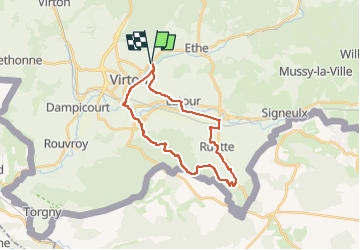
Départ/Retour: Virton (Pierard)
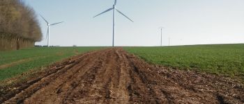
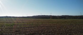
Endroits de passage : Solumont, Vieux-Virton, Saint-Mard, Bois de la Côte, l'Abîme de St-Mard, Croix Valentin, Stocfontaine, vue sur le parc d'éoliennes d'Allondrelle-la-Malmaison (France), Bois de la Côre ou de la Sente, Bois de Grandcourt, Grandcourt, Ruette, Etangs de Latour.

Vidéos:
1. https://vimeo.com/666720805   (Saint-Mard, Lat: 49,54371, Lng: 5,54342)
2. https://vimeo.com/746780539   (Parcs éoliens, Lat: 49,52641, Lng: 5,57342)
3. https://vimeo.com/746786117   (Grandcourt, Lat: 49,52090 , Lng: 5,60222 )

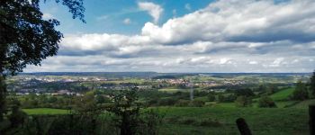
Remarque: très belle promenade avec de beaux points de vues. La difficulté majeure est la montée jusque dans le Bois de la Côte (alt. 403m).

Ref.
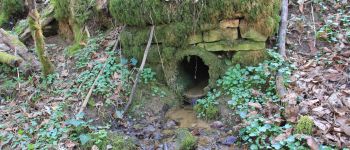
- http://biodiversite.wallonie.be/fr/6827-abime-de-saint-mard.html?IDD=335545293&IDC=2831#
- http://biodiversite.wallonie.be/fr/2201-abime-de-saint-mard.html?IDD=251660529&IDC=1881
- https://www.thewindpower.net/windfarm_fr_21688_allondrelle-la-malmaison.php
- http://jeanfrancoishusson.fr/inauguration-du-parc-eolien-d-allondrelle-la-malmaison/

(2021.11.23)

Hoogteprofiel

Foto's

93 fotos in totaal. Klik op een foto om ze allemaal in de galerij weer te geven.

POI's

POI Virton - Unnamed POI - Photo
Pascal L
VIRTON 
POI Virton - Les étangs de Latour - Photo
Pascal L
POI Virton - Sources du Bruzel - Photo
Pascal L
POI Saint-Pancré - Parcs éoliens des Deux Rivières (France) - Photo
Pascal L
POI Virton - Moulin Naisse à Virton - Photo
Pascal L
POI Virton - Château de Latour - Photo
Pascal L
POI Allondrelle-la-Malmaison - Parcs éoliens d'Allondrelle-la-Malmaison (France) - Photo
Pascal L
ALLONDRELLE-LA-MALMAISON 

Plaatsbepaling

Land:
Belgium
Regio :
Wallonië
Departement/Provincie :
Luxemburg
Gemeente :
Virton
Locatie:
Virton
Vertrek:(UTM)
684238 ; 5494495 (31U) N.

Wandeltochten in de omgeving

Tocht Stappen Virton - RB-Lu-17_Ethe_via-var-1-et-2-et-3 - Photo
Stappen
PRO

Stappen

Heel gemakkelijk
(3)
Virton, Wallonië, Luxemburg, Belgium
29 km | 35 km-effort
7h 33min
Ja
Tocht Mountainbike Virton - T2019-06-16-16-47 - Photo
Mountainbike
Pascal L

Mountainbike

Gemakkelijk
(1)
Virton, Wallonië, Luxemburg, Belgium
21 km | 26 km-effort
1h 40min
Ja
Tocht Stappen Virton - GAUME Balade  naturelle et historique - Photo
Stappen
julucasi

Stappen

Heel gemakkelijk
(1)
Virton, Wallonië, Luxemburg, Belgium
5,2 km | 6,8 km-effort
1h 16min
Ja
Tocht Te voet Virton - La Bajocienne - Photo
Te voet
GUIDE+

Te voet

Gemakkelijk
(1)
Virton, Wallonië, Luxemburg, Belgium
11 km | 14,5 km-effort
3h 17min
Ja
Tocht Te voet Virton - Chenois-Latour - Agrarische wandeling -  dorpen, appels en klein fruit - Photo
Te voet
GUIDE
DUPONT Rita

Te voet

Gemakkelijk
Virton, Wallonië, Luxemburg, Belgium
6,4 km | 7,7 km-effort
1h 45min
Ja
Tocht Stappen Virton - RB-Lu-17_Ethe_via-racc - Photo
Stappen
PRO

Stappen

Heel gemakkelijk
Virton, Wallonië, Luxemburg, Belgium
15,6 km | 19,3 km-effort
4h 8min
Ja
Tocht Stappen Virton - RB-Lu-17_Ethe - Photo
Stappen
PRO

Stappen

Heel gemakkelijk
Virton, Wallonië, Luxemburg, Belgium
22 km | 28 km-effort
5h 55min
Ja
Tocht Mountainbike Virton - Autour de Tintigny  -  Balade_VTT_54Kms - Photo
Mountainbike
Pascal L

Mountainbike

Zeer moeilijk
Virton, Wallonië, Luxemburg, Belgium
54 km | 64 km-effort
4h 25min
Ja
Tocht Mountainbike Virton - Monquintin  -  Balade_VTT_22Kms - Photo
Mountainbike
Pascal L

Mountainbike

Medium
Virton, Wallonië, Luxemburg, Belgium
22 km | 26 km-effort
1h 48min
Ja


Sluiten
Mijn abonnementen