


cabries.action

NADINE52
Gebruiker
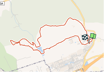

Lengte
6,2 km

Max. hoogte
262 m

Positief hoogteverschil
117 m
Km-Effort
7,8 km

Min. hoogte
207 m

Negatief hoogteverschil
119 m
Boucle
Ja
Datum van aanmaak :
2021-12-09 10:20:47.773
Laatste wijziging :
2021-12-09 12:06:01.477
1h30
Moeilijkheid : Medium

Gratisgps-wandelapplicatie
 SityTrail
IGN / Geografische instituten
SityTrail Plus
De wereld gaat voor u open
Over ons
Tocht Stappen van 6,2 km beschikbaar op Provence-Alpes-Côte d'Azur, Bouches-du-Rhône, Cabriès. Deze tocht wordt voorgesteld door NADINE52.
Plaatsbepaling
Land:
France
Regio :
Provence-Alpes-Côte d'Azur
Departement/Provincie :
Bouches-du-Rhône
Gemeente :
Cabriès
Locatie:
Unknown
Vertrek:(Dec)
Vertrek:(UTM)
691745 ; 4810835 (31T) N.
Opmerkingen