


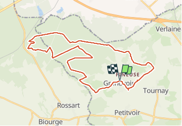
GRANDVOIR

BVB
Gebruiker

Lengte
20 km

Max. hoogte
480 m

Positief hoogteverschil
385 m
Km-Effort
25 km

Min. hoogte
380 m

Negatief hoogteverschil
389 m
Boucle
Ja
Datum van aanmaak :
2021-12-30 09:52:25.429
Laatste wijziging :
2021-12-30 14:43:27.394
4h17
Moeilijkheid : Gemakkelijk

Gratisgps-wandelapplicatie
 SityTrail
IGN / Geografische instituten
SityTrail Plus
De wereld gaat voor u open
Over ons
Tocht Stappen van 20 km beschikbaar op Wallonië, Luxemburg, Neufchâteau. Deze tocht wordt voorgesteld door BVB.
Beschrijving
Promenade autour de GRANDVOIR.
Pas de village à traverser.
Bien veiller à se renseigner préalablement sur les risques de chasse.
Plaatsbepaling
Land:
Belgium
Regio :
Wallonië
Departement/Provincie :
Luxemburg
Gemeente :
Neufchâteau
Locatie:
Unknown
Vertrek:(Dec)
Vertrek:(UTM)
670526 ; 5525606 (31U) N.
Opmerkingen