Tocht Stappen Conques-sur-Orbiel - SityTrail - 2019-12-08 Conques sur Orbiel -Les Capitelles - Photo

SityTrail - 2019-12-08 Conques sur Orbiel -Les Capitelles

 PI11
PI11

Gebruiker

© OpenStreetMap contributors
Lengte
Lengte
10 km
Max. hoogte
Max. hoogte
280 m
Positief hoogteverschil
240 m
Km-Effort
Km-Effort  
13,2 km
Min. hoogte
Min. hoogte
142 m
Negatief hoogteverschil
241 m
Boucle
Boucle
Ja
Datum van aanmaak :
2021-12-31 21:23:23.14
Laatste wijziging :
2021-12-31 21:47:32.843

(0 Bericht)

Stappen
Stappen
2h59
Moeilijkheid : Moeilijk

Scan deze QR-code om de tocht te openen in de SityTrail-applicatie

Gratisgps-wandelapplicatie

Logo SityTrail SityTrail

IGN / Geografische instituten

SityTrail uit de App Store downloaden SityTrail uit Google Play downloaden

Logo SityTrail SityTrail World

De wereld gaat voor u open

SityTrail uit de App Store downloaden SityTrail uit Google Play downloaden SityTrail op Huawei AppGallery downloaden

Over ons

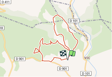
Tocht Stappen van 10 km beschikbaar op Occitanië, Aude, Conques-sur-Orbiel. Deze tocht wordt voorgesteld door PI11.

Beschrijving

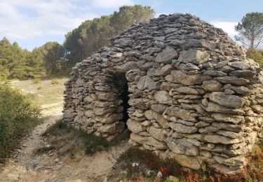
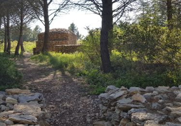
On 300 hectares, an association of Conques-sur-Orbiel has restored a large number of capitelles which were used in time to shelter the peasants when they worked on these inhospitable lands. The rocks torn from the earth during the work were used to set up these shelters. You will come across the capitelles during this hike and see the walls of Aribaud.

Hoogteprofiel

Plaatsbepaling

Land:
France
Regio :
Occitanië
Departement/Provincie :
Aude
Gemeente :
Conques-sur-Orbiel
Locatie:
Unknown
Vertrek:(UTM)
450606 ; 4792777 (31T) N.

Wandeltochten in de omgeving

Tocht Mountainbike Villegly - Cap Nore 2009 60km - Photo
Mountainbike
tracegps

Mountainbike

Moeilijk
(1)
Villegly, Occitanië, Aude, France
61 km | 84 km-effort
5h 0min
Neen
Tocht Stappen Villegly - Wisigoths  - Photo
Stappen
GUIDE
Ada11

Stappen

Gemakkelijk
Villegly, Occitanië, Aude, France
19,7 km | 24 km-effort
4h 37min
Ja
Tocht Stappen Villegailhenc - Villegailhenc Conques Aragon - Photo
Stappen
GUIDE
Ada11

Stappen

Medium
Villegailhenc, Occitanië, Aude, France
23 km | 29 km-effort
5h 45min
Ja
Tocht Te voet Conques-sur-Orbiel - Conques-Les Capitelles - Photo
Te voet
dufland

Te voet

Gemakkelijk
(2)
Conques-sur-Orbiel, Occitanië, Aude, France
6,4 km | 7,7 km-effort
2h 30min
Ja
Tocht Stappen Conques-sur-Orbiel - village celte - Photo
Stappen
oliviercaty

Stappen

Gemakkelijk
(1)
Conques-sur-Orbiel, Occitanië, Aude, France
3,9 km | 4,8 km-effort
1h 48min
Ja
Tocht Stappen Sallèles-Cabardès - Sallèles Cabardès - Pradellles Cabardès - Pic du Nore-   - Photo
Stappen
jacques delaporte

Stappen

Zeer moeilijk
Sallèles-Cabardès, Occitanië, Aude, France
65 km | 0 m-effort
23h 36min
Ja
Tocht Stappen Sallèles-Cabardès - Reco Le Pic de Nore  - Photo
Stappen
jacques delaporte

Stappen

Zeer moeilijk
Sallèles-Cabardès, Occitanië, Aude, France
54 km | 79 km-effort
21h 27min
Ja
Tocht Stappen Conques-sur-Orbiel - les capitales à Conques - Photo
Stappen
bernardbelmas

Stappen

Gemakkelijk
Conques-sur-Orbiel, Occitanië, Aude, France
4,3 km | 5,2 km-effort
1h 36min
Ja
Tocht Stappen Villegly - la combe de St Martin à Villegly - Photo
Stappen
bernardbelmas

Stappen

Gemakkelijk
Villegly, Occitanië, Aude, France
6,2 km | 7,7 km-effort
2h 45min
Ja


Sluiten
Mijn abonnementen