


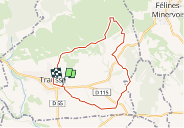
Trausse Vignes et garrigue VM

dufland
Gebruiker

Lengte
8,2 km

Max. hoogte
228 m

Positief hoogteverschil
128 m
Km-Effort
9,9 km

Min. hoogte
129 m

Negatief hoogteverschil
128 m
Boucle
Ja
Datum van aanmaak :
2022-01-05 13:57:34.775
Laatste wijziging :
2024-02-13 17:35:46.952
2h14
Moeilijkheid : Gemakkelijk

Gratisgps-wandelapplicatie
 SityTrail
IGN / Geografische instituten
SityTrail Plus
De wereld gaat voor u open
Over ons
Tocht Te voet van 8,2 km beschikbaar op Occitanië, Aude, Trausse. Deze tocht wordt voorgesteld door dufland.
Plaatsbepaling
Land:
France
Regio :
Occitanië
Departement/Provincie :
Aude
Gemeente :
Trausse
Locatie:
Unknown
Vertrek:(Dec)
Vertrek:(UTM)
464798 ; 4795512 (31T) N.
Opmerkingen