


TREMBLANT MONGES CADIERE RETOUR

clintest
Gebruiker

Lengte
14,2 km

Max. hoogte
364 m

Positief hoogteverschil
556 m
Km-Effort
22 km

Min. hoogte
15 m

Negatief hoogteverschil
555 m
Boucle
Ja
Datum van aanmaak :
2022-01-11 10:01:12.613
Laatste wijziging :
2022-01-11 10:01:47.317
4h55
Moeilijkheid : Medium

Gratisgps-wandelapplicatie
 SityTrail
IGN / Geografische instituten
SityTrail Plus
De wereld gaat voor u open
Over ons
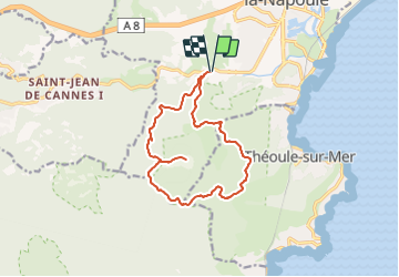
Tocht Te voet van 14,2 km beschikbaar op Provence-Alpes-Côte d'Azur, Alpes-Maritimes, Mandelieu-la-Napoule. Deze tocht wordt voorgesteld door clintest.
Plaatsbepaling
Land:
France
Regio :
Provence-Alpes-Côte d'Azur
Departement/Provincie :
Alpes-Maritimes
Gemeente :
Mandelieu-la-Napoule
Locatie:
Unknown
Vertrek:(Dec)
Vertrek:(UTM)
331337 ; 4821230 (32T) N.
Opmerkingen