


69 rontalon tr

trietsch
Gebruiker
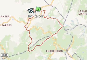

Lengte
8,4 km

Max. hoogte
618 m

Positief hoogteverschil
292 m
Km-Effort
12,2 km

Min. hoogte
406 m

Negatief hoogteverschil
278 m
Boucle
Ja
Datum van aanmaak :
2022-01-11 08:52:16.0
Laatste wijziging :
2022-01-11 11:33:29.682
2h12
Moeilijkheid : Gemakkelijk

Gratisgps-wandelapplicatie
 SityTrail
IGN / Geografische instituten
SityTrail Plus
De wereld gaat voor u open
Over ons
Tocht Stappen van 8,4 km beschikbaar op Auvergne-Rhône-Alpes, Rhône, Rontalon. Deze tocht wordt voorgesteld door trietsch.
Plaatsbepaling
Land:
France
Regio :
Auvergne-Rhône-Alpes
Departement/Provincie :
Rhône
Gemeente :
Rontalon
Locatie:
Unknown
Vertrek:(Dec)
Vertrek:(UTM)
627179 ; 5057725 (31T) N.
Opmerkingen