


seveyrac

bouscaillou
Gebruiker
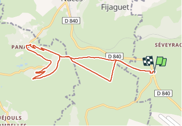

Lengte
10,9 km

Max. hoogte
609 m

Positief hoogteverschil
233 m
Km-Effort
14 km

Min. hoogte
456 m

Negatief hoogteverschil
234 m
Boucle
Ja
Datum van aanmaak :
2022-01-18 13:05:11.066
Laatste wijziging :
2022-01-18 15:34:32.461
2h28
Moeilijkheid : Heel gemakkelijk

Gratisgps-wandelapplicatie
 SityTrail
IGN / Geografische instituten
SityTrail Plus
De wereld gaat voor u open
Over ons
Tocht Noords wandelen van 10,9 km beschikbaar op Occitanië, Aveyron, Salles-la-Source. Deze tocht wordt voorgesteld door bouscaillou.
Plaatsbepaling
Land:
France
Regio :
Occitanië
Departement/Provincie :
Aveyron
Gemeente :
Salles-la-Source
Locatie:
Unknown
Vertrek:(Dec)
Vertrek:(UTM)
457853 ; 4919123 (31T) N.
Opmerkingen