


hanches la boissiere école

topophil
Gebruiker

Lengte
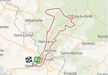
35 km

Max. hoogte
183 m

Positief hoogteverschil
379 m
Km-Effort
40 km

Min. hoogte
109 m

Negatief hoogteverschil
379 m
Boucle
Ja
Datum van aanmaak :
2022-02-06 08:06:58.455
Laatste wijziging :
2022-02-06 11:00:29.439
2h52
Moeilijkheid : Moeilijk

Gratisgps-wandelapplicatie
 SityTrail
IGN / Geografische instituten
SityTrail Plus
De wereld gaat voor u open
Over ons
Tocht Mountainbike van 35 km beschikbaar op Centre-Val de Loire, Eure-et-Loir, Hanches. Deze tocht wordt voorgesteld door topophil.
Plaatsbepaling
Land:
France
Regio :
Centre-Val de Loire
Departement/Provincie :
Eure-et-Loir
Gemeente :
Hanches
Locatie:
Unknown
Vertrek:(Dec)
Vertrek:(UTM)
400092 ; 5383829 (31U) N.
Opmerkingen