


2022-02-07_15h57m19_Pic_Coudère_-_Pic_d'Engral-13521318-1644245335-617

chrisgps
Gebruiker
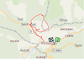

Lengte
9,7 km

Max. hoogte
1315 m

Positief hoogteverschil
699 m
Km-Effort
19,1 km

Min. hoogte
706 m

Negatief hoogteverschil
699 m
Boucle
Ja
Datum van aanmaak :
2022-02-07 14:57:20.17
Laatste wijziging :
2022-02-07 14:57:23.688

Gratisgps-wandelapplicatie
 SityTrail
IGN / Geografische instituten
SityTrail Plus
De wereld gaat voor u open
Over ons
Tocht van 9,7 km beschikbaar op Occitanië, Ariège, Val-de-Sos. Deze tocht wordt voorgesteld door chrisgps.
Plaatsbepaling
Land:
France
Regio :
Occitanië
Departement/Provincie :
Ariège
Gemeente :
Val-de-Sos
Locatie:
Unknown
Vertrek:(Dec)
Vertrek:(UTM)
377381 ; 4736171 (31T) N.
Opmerkingen