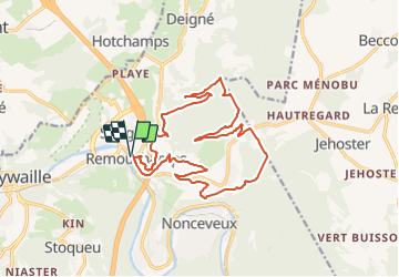
Tocht Te voet Aywaille - De steengroeve van Menire -  Zeys - Photo

De steengroeve van Menire - Zeys

Randonnées du CGT GUIDE+

© OpenStreetMap contributors
Lengte
Lengte
16,6 km
Max. hoogte
Max. hoogte
385 m
Positief hoogteverschil
523 m
Km-Effort
Km-Effort  
24 km
Min. hoogte
Min. hoogte
130 m
Negatief hoogteverschil
523 m
Boucle
Boucle
Ja
Datum van aanmaak :
08/02/2022 11:21
Laatste wijziging :
21/02/2022 10:02

(0 Bericht)

Te voet
Te voet
5h21
Moeilijkheid : Medium

Scan deze QR-code om de tocht te openen in de SityTrail-applicatie

Gratisgps-wandelapplicatie

Logo SityTrail SityTrail

IGN / Geografische instituten

SityTrail uit de App Store downloaden SityTrail uit Google Play downloaden

Logo SityTrail SityTrail Plus

De wereld gaat voor u open

SityTrail uit de App Store downloaden SityTrail uit Google Play downloaden SityTrail op Huawei AppGallery downloaden

Over ons

Tocht Te voet van 16,6 km beschikbaar op Wallonië, Luik, Aywaille. Deze tocht wordt voorgesteld door Commissariat général au Tourisme.

Hoogteprofiel

Foto's

Plaatsbepaling

Land:
Belgium
Regio :
Wallonië
Departement/Provincie :
Luik
Gemeente :
Aywaille
Locatie:
Unknown
Vertrek:(Dec)
Vertrek:(UTM)
692339 ; 5595488 (31U) N.


Sluiten
Mijn abonnementen