


RSJurançonle gave2022

LouisROGER
Gebruiker GUIDE
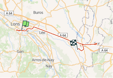

Lengte
46 km

Max. hoogte
425 m

Positief hoogteverschil
475 m
Km-Effort
52 km

Min. hoogte
163 m

Negatief hoogteverschil
305 m
Boucle
Neen
Datum van aanmaak :
2022-02-08 13:11:57.273
Laatste wijziging :
2022-02-08 17:13:26.43
1h35
Moeilijkheid : Gemakkelijk

Gratisgps-wandelapplicatie
 SityTrail
IGN / Geografische instituten
SityTrail Plus
De wereld gaat voor u open
Over ons
Tocht Stappen van 46 km beschikbaar op Nieuw-Aquitanië, Pyrénées-Atlantiques, Pau. Deze tocht wordt voorgesteld door LouisROGER.
Plaatsbepaling
Land:
France
Regio :
Nieuw-Aquitanië
Departement/Provincie :
Pyrénées-Atlantiques
Gemeente :
Pau
Locatie:
Unknown
Vertrek:(Dec)
Vertrek:(UTM)
712399 ; 4796728 (30T) N.
Opmerkingen