Tocht Te voet Dippach - Auto-Pédestre Dippach - Photo

Auto-Pédestre Dippach

Tous les sentiers balisés d’Europe GUIDE+

© OpenStreetMap contributors
Lengte
Lengte
4,4 km
Max. hoogte
Max. hoogte
375 m
Positief hoogteverschil
107 m
Km-Effort
Km-Effort  
5,7 km
Min. hoogte
Min. hoogte
316 m
Negatief hoogteverschil
76 m
Boucle
Boucle
Neen
Markering
Markering
Datum van aanmaak :
2022-02-09 15:19:35.078
Laatste wijziging :
2022-02-09 18:01:04.719

(0 Bericht)

Te voet
Te voet
1h17
Moeilijkheid : Gemakkelijk

Scan deze QR-code om de tocht te openen in de SityTrail-applicatie

Gratisgps-wandelapplicatie

Logo SityTrail SityTrail

IGN / Geografische instituten

SityTrail uit de App Store downloaden SityTrail uit Google Play downloaden

Logo SityTrail SityTrail Plus

De wereld gaat voor u open

SityTrail uit de App Store downloaden SityTrail uit Google Play downloaden SityTrail op Huawei AppGallery downloaden

Over ons

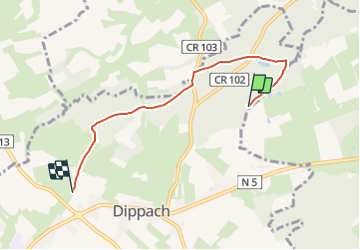
Tocht Te voet van 4,4 km beschikbaar op Onbekend, Canton Capellen, Dippach. Deze tocht wordt voorgesteld door SityTrail - itinéraires balisés pédestres.

Beschrijving

Trail created by Ministère de l´Économie.


Website: https://map.geoportail.lu/theme/tourisme?fid=176_1306417

Hoogteprofiel

Foto's

Plaatsbepaling

Land:
Luxembourg
Regio :
Onbekend
Departement/Provincie :
Canton Capellen
Gemeente :
Dippach
Locatie:
Unknown
Vertrek:(UTM)
716765 ; 5498380 (31U) N.


Sluiten
Mijn abonnementen