


La Planche Ballon

PatriceCocuaud
Gebruiker
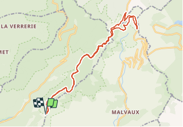

Lengte
20 km

Max. hoogte
1171 m

Positief hoogteverschil
544 m
Km-Effort
27 km

Min. hoogte
949 m

Negatief hoogteverschil
544 m
Boucle
Ja
Datum van aanmaak :
2022-02-08 13:10:59.883
Laatste wijziging :
2022-02-11 14:32:23.08
1h49
Moeilijkheid : Heel gemakkelijk

Gratisgps-wandelapplicatie
 SityTrail
IGN / Geografische instituten
SityTrail Plus
De wereld gaat voor u open
Over ons
Tocht Ezelwandeling van 20 km beschikbaar op Bourgondië-Franche-Comté, Haute-Saône, Plancher-les-Mines. Deze tocht wordt voorgesteld door PatriceCocuaud.
Plaatsbepaling
Land:
France
Regio :
Bourgondië-Franche-Comté
Departement/Provincie :
Haute-Saône
Gemeente :
Plancher-les-Mines
Locatie:
Unknown
Vertrek:(Dec)
Vertrek:(UTM)
333651 ; 5293757 (32T) N.
Opmerkingen