


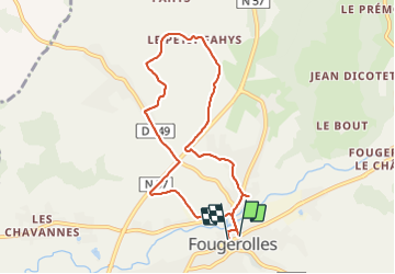
Fougerolles... petit fays

PatriceCocuaud
Gebruiker

Lengte
7,8 km

Max. hoogte
355 m

Positief hoogteverschil
87 m
Km-Effort
8,9 km

Min. hoogte
300 m

Negatief hoogteverschil
87 m
Boucle
Ja
Datum van aanmaak :
2022-02-13 13:35:46.984
Laatste wijziging :
2022-02-13 15:31:46.911
1h55
Moeilijkheid : Gemakkelijk

Gratisgps-wandelapplicatie
 SityTrail
IGN / Geografische instituten
SityTrail Plus
De wereld gaat voor u open
Over ons
Tocht Stappen van 7,8 km beschikbaar op Bourgondië-Franche-Comté, Haute-Saône, Fougerolles-Saint-Valbert. Deze tocht wordt voorgesteld door PatriceCocuaud.
Plaatsbepaling
Land:
France
Regio :
Bourgondië-Franche-Comté
Departement/Provincie :
Haute-Saône
Gemeente :
Fougerolles-Saint-Valbert
Locatie:
Unknown
Vertrek:(Dec)
Vertrek:(UTM)
306042 ; 5306970 (32T) N.
Opmerkingen