


Danikerbergroute

SityTrail - itinéraires balisés pédestres
Tous les sentiers balisés d’Europe GUIDE+
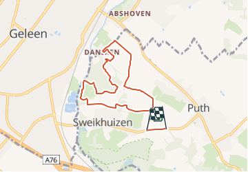

Lengte
6,9 km

Max. hoogte
109 m

Positief hoogteverschil
115 m
Km-Effort
8,4 km

Min. hoogte
52 m

Negatief hoogteverschil
120 m
Boucle
Neen

Markering
Datum van aanmaak :
2022-02-14 14:28:12.979
Laatste wijziging :
2022-02-14 14:28:12.979
1h54
Moeilijkheid : Gemakkelijk

Gratisgps-wandelapplicatie
 SityTrail
IGN / Geografische instituten
SityTrail Plus
De wereld gaat voor u open
Over ons
Tocht Te voet van 6,9 km beschikbaar op Limburg, Onbekend, Beekdaelen. Deze tocht wordt voorgesteld door SityTrail - itinéraires balisés pédestres.
Beschrijving
Trail created by Gemeente Schinnen.
Foto's


Plaatsbepaling
Land:
Netherlands
Regio :
Limburg
Departement/Provincie :
Onbekend
Gemeente :
Beekdaelen
Locatie:
Unknown
Vertrek:(Dec)
Vertrek:(UTM)
700695 ; 5648376 (31U) N.
Opmerkingen