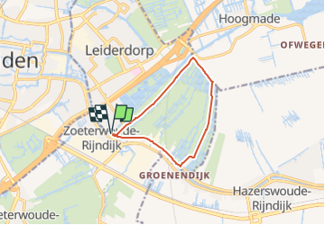
Tocht Te voet Leiderdorp - Achthovenroute - Photo

Tous les sentiers balisés d’Europe GUIDE+

© OpenStreetMap contributors
Lengte
Lengte
8,5 km
Max. hoogte
Max. hoogte
4 m
Positief hoogteverschil
24 m
Km-Effort
Km-Effort  
8,8 km
Min. hoogte
Min. hoogte
-5 m
Negatief hoogteverschil
24 m
Boucle
Boucle
Ja
Markering
Markering
Datum van aanmaak :
2022-02-14 14:53:48.283
Laatste wijziging :
2022-02-14 14:53:48.283

(0 Bericht)

Te voet
Te voet
2h00
Moeilijkheid : Gemakkelijk

Scan deze QR-code om de tocht te openen in de SityTrail-applicatie

Gratisgps-wandelapplicatie

Logo SityTrail SityTrail

IGN / Geografische instituten

SityTrail uit de App Store downloaden SityTrail uit Google Play downloaden

Logo SityTrail SityTrail Plus

De wereld gaat voor u open

SityTrail uit de App Store downloaden SityTrail uit Google Play downloaden SityTrail op Huawei AppGallery downloaden

Over ons

Tocht Te voet van 8,5 km beschikbaar op Zuid-Holland, Onbekend, Leiderdorp. Deze tocht wordt voorgesteld door SityTrail - itinéraires balisés pédestres.

Beschrijving

Trail created by Land van Wijk en Wouden.

Boerenlandpad, deel van route gesloten in broedseizoen / access: permissive / access:conditional no @ (Mar 15-Jun 15)


Website: http://www.landvanwijkenwouden.nl/uploads/bord_Achthoven_LR.pdf

Hoogteprofiel

Plaatsbepaling

Land:
Netherlands
Regio :
Zuid-Holland
Departement/Provincie :
Onbekend
Gemeente :
Leiderdorp
Locatie:
Unknown
Vertrek:(UTM)
604794 ; 5777962 (31U) N.


Sluiten
Mijn abonnementen