


berck plage

Phil55
Gebruiker
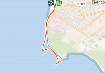

Lengte
2,9 km

Max. hoogte
11 m

Positief hoogteverschil
22 m
Km-Effort
3,2 km

Min. hoogte
-1 m

Negatief hoogteverschil
18 m
Boucle
Ja
Datum van aanmaak :
2022-02-14 14:19:21.682
Laatste wijziging :
2022-02-14 15:37:26.364
1h17
Moeilijkheid : Gemakkelijk

Gratisgps-wandelapplicatie
 SityTrail
IGN / Geografische instituten
SityTrail Plus
De wereld gaat voor u open
Over ons
Tocht Stappen van 2,9 km beschikbaar op Hauts-de-France, Pas-de-Calais, Berck. Deze tocht wordt voorgesteld door Phil55.
Plaatsbepaling
Land:
France
Regio :
Hauts-de-France
Departement/Provincie :
Pas-de-Calais
Gemeente :
Berck
Locatie:
Unknown
Vertrek:(Dec)
Vertrek:(UTM)
397540 ; 5584523 (31U) N.
Opmerkingen