


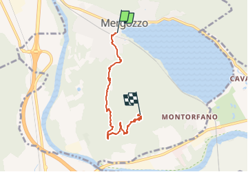
A58 - Mergozzo - Linea Cadorna - Mont'Orfano vetta

SityTrail - itinéraires balisés pédestres
Tous les sentiers balisés d’Europe GUIDE+


2h24
Moeilijkheid : Gemakkelijk

Gratisgps-wandelapplicatie
 SityTrail
IGN / Geografische instituten
SityTrail Plus
De wereld gaat voor u open
Over ons
Tocht Te voet van 4,8 km beschikbaar op Piëmont, Verbano-Cusio-Ossola, Mergozzo. Deze tocht wordt voorgesteld door SityTrail - itinéraires balisés pédestres.
Beschrijving
Relation with photos (click on → Web site) mantained by CAI Sezioni Est Monterosa
Symbol: some old white red flag
Foto's


Plaatsbepaling
Opmerkingen