


IT-G01

SityTrail - itinéraires balisés pédestres
Tous les sentiers balisés d’Europe GUIDE+

Lengte
3,3 km

Max. hoogte
341 m

Positief hoogteverschil
44 m
Km-Effort
3,7 km

Min. hoogte
300 m

Negatief hoogteverschil
7 m
Boucle
Neen

Markering
Datum van aanmaak :
2022-02-15 15:22:57.469
Laatste wijziging :
2022-03-01 16:02:09.946
51m
Moeilijkheid : Gemakkelijk

Gratisgps-wandelapplicatie
 SityTrail
IGN / Geografische instituten
SityTrail Plus
De wereld gaat voor u open
Over ons
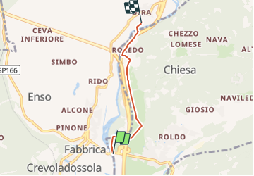
Tocht Te voet van 3,3 km beschikbaar op Piëmont, Verbano-Cusio-Ossola, Montecrestese. Deze tocht wordt voorgesteld door SityTrail - itinéraires balisés pédestres.
Plaatsbepaling
Land:
Italy
Regio :
Piëmont
Departement/Provincie :
Verbano-Cusio-Ossola
Gemeente :
Montecrestese
Locatie:
Unknown
Vertrek:(Dec)
Vertrek:(UTM)
446664 ; 5111059 (32T) N.
Opmerkingen