


Ru de By

SityTrail - itinéraires balisés pédestres
Tous les sentiers balisés d’Europe GUIDE+

Lengte
9,5 km

Max. hoogte
2210 m

Positief hoogteverschil
234 m
Km-Effort
12,2 km

Min. hoogte
2073 m

Negatief hoogteverschil
101 m
Boucle
Neen

Markering
Datum van aanmaak :
2022-02-15 17:20:38.775
Laatste wijziging :
2022-03-01 20:36:15.871
2h45
Moeilijkheid : Gemakkelijk

Gratisgps-wandelapplicatie
 SityTrail
IGN / Geografische instituten
SityTrail Plus
De wereld gaat voor u open
Over ons
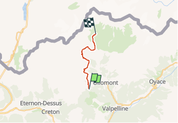
Tocht Te voet van 9,5 km beschikbaar op Valle d'Aosta, Onbekend, Doues. Deze tocht wordt voorgesteld door SityTrail - itinéraires balisés pédestres.
Foto's


Plaatsbepaling
Land:
Italy
Regio :
Valle d'Aosta
Departement/Provincie :
Onbekend
Gemeente :
Doues
Locatie:
Unknown
Vertrek:(Dec)
Vertrek:(UTM)
367056 ; 5078023 (32T) N.
Opmerkingen