Tocht Te voet Lay-Saint-Christophe - Circuit L - Photo

Tous les sentiers balisés d’Europe PRO

© OpenStreetMap contributors
Lengte
Lengte
14,7 km
Max. hoogte
Max. hoogte
406 m
Positief hoogteverschil
280 m
Km-Effort
Km-Effort  
18,5 km
Min. hoogte
Min. hoogte
200 m
Negatief hoogteverschil
277 m
Boucle
Boucle
Ja
Markering
Markering
Datum van aanmaak :
2022-02-15 19:20:38.225
Laatste wijziging :
2022-03-02 23:48:42.998

(0 Bericht)

Te voet
Te voet
4h11
Moeilijkheid : Gemakkelijk

Scan deze QR-code om de tocht te openen in de SityTrail-applicatie

Gratisgps-wandelapplicatie

Logo SityTrail SityTrail

IGN / Geografische instituten

SityTrail uit de App Store downloaden SityTrail uit Google Play downloaden

Logo SityTrail SityTrail World

De wereld gaat voor u open

SityTrail uit de App Store downloaden SityTrail uit Google Play downloaden SityTrail op Huawei AppGallery downloaden

Over ons

Tocht Te voet van 14,7 km beschikbaar op Grand Est, Meurthe-et-Moselle, Lay-Saint-Christophe. Deze tocht wordt voorgesteld door SityTrail - itinéraires balisés pédestres.

Beschrijving

Trail created by Club Alpin.

Symbol: disque jaune

Foto's

Plaatsbepaling

Land:
France
Regio :
Grand Est
Departement/Provincie :
Meurthe-et-Moselle
Gemeente :
Lay-Saint-Christophe
Locatie:
Unknown
Vertrek:(UTM)
293335 ; 5405491 (32U) N.

Wandeltochten in de omgeving

Tocht Te voet Champigneulles - Circuit du Val Saint-Barthélémy - Photo
Te voet
PRO

Te voet

Gemakkelijk
Champigneulles, Grand Est, Meurthe-et-Moselle, France
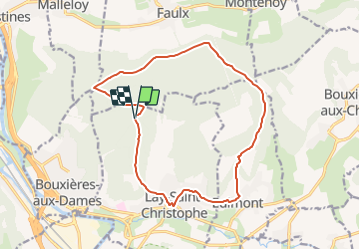
7 km | 8,6 km-effort
1h 57min
Ja
Tocht Fietstoerisme Frouard - 4ème rando vélo Frouard - Lagarde 62 km - Photo
Fietstoerisme
GUIDE
jeanmarcMasson

Fietstoerisme

Zeer moeilijk
Frouard, Grand Est, Meurthe-et-Moselle, France
62 km | 67 km-effort
4h 32min
Neen
Tocht Te voet Champigneulles - Circuit du Vallum de la Fourasse - Photo
Te voet
PRO

Te voet

Gemakkelijk
Champigneulles, Grand Est, Meurthe-et-Moselle, France
3,3 km | 4,9 km-effort
1h 6min
Ja
Tocht Te voet Bouxières-aux-Dames - Circuit moyenne ceinture - Photo
Te voet
PRO

Te voet

Gemakkelijk
Bouxières-aux-Dames, Grand Est, Meurthe-et-Moselle, France
3,8 km | 5,3 km-effort
1h 12min
Ja
Tocht Stappen Montenoy - MONTENOY - LE COL DE VASSUCHAMP - Photo
Stappen
jean-marie.parachini

Stappen

Gemakkelijk
Montenoy, Grand Est, Meurthe-et-Moselle, France
12,4 km | 16,4 km-effort
4h 33min
Ja
Tocht Stappen Eulmont - 2020-12-11_18h42m13_Eulmont_La tour du Crany_10kms - Photo
Stappen
Marin B

Stappen

Moeilijk
(1)
Eulmont, Grand Est, Meurthe-et-Moselle, France
9,6 km | 12,6 km-effort
2h 51min
Ja
Tocht Stappen Champigneulles - Champigneulles_9,5kms - Photo
Stappen
ZAMBAUX

Stappen

Gemakkelijk
(3)
Champigneulles, Grand Est, Meurthe-et-Moselle, France
9,3 km | 11,4 km-effort
2h 28min
Ja
Tocht Stappen Frouard - Foret de Haye - Photo
Stappen
webmammuth

Stappen

Heel gemakkelijk
Frouard, Grand Est, Meurthe-et-Moselle, France
18 km | 23 km-effort
4h 15min
Ja
Tocht Stappen Lay-Saint-Christophe - lay saint Christophe le moulin noir - Photo
Stappen
jean-marie.parachini

Stappen

Gemakkelijk
Lay-Saint-Christophe, Grand Est, Meurthe-et-Moselle, France
12,4 km | 14 km-effort
3h 25min
Ja


Sluiten
Mijn abonnementen