Tocht Te voet Manhac - Circuit 4 - Au fil de l'eau - Photo

Circuit 4 - Au fil de l'eau

Tous les sentiers balisés d’Europe PRO

© OpenStreetMap contributors
Lengte
Lengte
6,4 km
Max. hoogte
Max. hoogte
806 m
Positief hoogteverschil
156 m
Km-Effort
Km-Effort  
8,5 km
Min. hoogte
Min. hoogte
707 m
Negatief hoogteverschil
164 m
Boucle
Boucle
Neen
Markering
Markering
Datum van aanmaak :
2022-02-15 19:25:05.358
Laatste wijziging :
2022-03-02 23:54:27.882

(0 Bericht)

Te voet
Te voet
1h56
Moeilijkheid : Gemakkelijk

Scan deze QR-code om de tocht te openen in de SityTrail-applicatie

Gratisgps-wandelapplicatie

Logo SityTrail SityTrail

IGN / Geografische instituten

SityTrail uit de App Store downloaden SityTrail uit Google Play downloaden

Logo SityTrail SityTrail World

De wereld gaat voor u open

SityTrail uit de App Store downloaden SityTrail uit Google Play downloaden SityTrail op Huawei AppGallery downloaden

Over ons

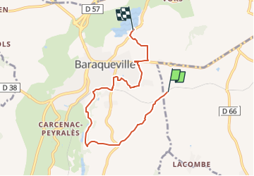
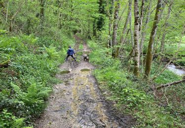
Tocht Te voet van 6,4 km beschikbaar op Occitanië, Aveyron, Manhac. Deze tocht wordt voorgesteld door SityTrail - itinéraires balisés pédestres.

Beschrijving

Le Ségala Au Pays des Cent vallées - 5ème édition Collection : Les belles balades de l'Aveyron Ce guide vous propose de découvrir le Ségala à trav

Website: http://www.baraqueville.fr/cadre-de-vie/tourisme/promenade

Foto's

Plaatsbepaling

Land:
France
Regio :
Occitanië
Departement/Provincie :
Aveyron
Gemeente :
Manhac
Locatie:
Unknown
Vertrek:(UTM)
456021 ; 4902220 (31T) N.

Wandeltochten in de omgeving

Tocht Te voet Baraqueville - Circuit 3 - La fontainte romaine - Photo
Te voet
PRO

Te voet

Gemakkelijk
Baraqueville, Occitanië, Aveyron, France
5,3 km | 6,7 km-effort
1h 30min
Ja
Tocht Te voet Baraqueville - Circuit 2 - Petite balade ombragée - Photo
Te voet
PRO

Te voet

Gemakkelijk
Baraqueville, Occitanië, Aveyron, France
4 km | 4,8 km-effort
1h 6min
Ja
Tocht Stappen Baraqueville - Les Crouzets au bord du ruisseau - Photo
Stappen
Benoît Marquès

Stappen

Medium
(1)
Baraqueville, Occitanië, Aveyron, France
5,2 km | 7,1 km-effort
1h 37min
Ja
Tocht Stappen Manhac - Manhac, au coeur du Ségala - Photo
Stappen
tracegps

Stappen

Medium
(1)
Manhac, Occitanië, Aveyron, France
11,3 km | 16,1 km-effort
3h 0min
Ja
Tocht Stappen Camboulazet - camboulazet 3 - Photo
Stappen
Frayssinet

Stappen

Moeilijk
Camboulazet, Occitanië, Aveyron, France
11,1 km | 15,1 km-effort
3h 26min
Ja
Tocht Stappen Camboulazet - Le ruisseau en botte - Photo
Stappen
Benoît Marquès

Stappen

Gemakkelijk
Camboulazet, Occitanië, Aveyron, France
4,1 km | 5,4 km-effort
1h 32min
Neen
Tocht Andere activiteiten Baraqueville - Baraqueville - Photo
Andere activiteiten
danou56

Andere activiteiten

Heel gemakkelijk
Baraqueville, Occitanië, Aveyron, France
3,3 km | 3,9 km-effort
1h 0min
Ja
Tocht Noords wandelen Baraqueville - val de lenne - Photo
Noords wandelen
bouscaillou

Noords wandelen

Heel gemakkelijk
Baraqueville, Occitanië, Aveyron, France
8,6 km | 10,7 km-effort
2h 0min
Ja
Tocht Noords wandelen Baraqueville - baraqueville 3 - Photo
Noords wandelen
bouscaillou

Noords wandelen

Heel gemakkelijk
Baraqueville, Occitanië, Aveyron, France
6,6 km | 8,3 km-effort
1h 34min
Ja


Sluiten
Mijn abonnementen