


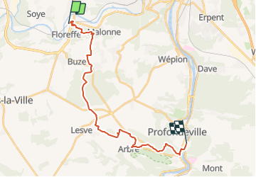
de la gare de Floreffe à la gare de Lustin de Philippe et Gaëlle

pasvraimec
Gebruiker

Lengte
21 km

Max. hoogte
264 m

Positief hoogteverschil
523 m
Km-Effort
28 km

Min. hoogte
83 m

Negatief hoogteverschil
524 m
Boucle
Neen
Datum van aanmaak :
2022-02-16 15:44:37.317
Laatste wijziging :
2022-02-16 15:46:24.003
6h22
Moeilijkheid : Medium

Gratisgps-wandelapplicatie
 SityTrail
IGN / Geografische instituten
SityTrail Plus
De wereld gaat voor u open
Over ons
Tocht Te voet van 21 km beschikbaar op Wallonië, Namen, Floreffe. Deze tocht wordt voorgesteld door pasvraimec.
Beschrijving
21 km en passant par le bois de Haute Marlagne
Plaatsbepaling
Land:
Belgium
Regio :
Wallonië
Departement/Provincie :
Namen
Gemeente :
Floreffe
Locatie:
Floreffe
Vertrek:(Dec)
Vertrek:(UTM)
625152 ; 5589408 (31U) N.
Opmerkingen