


2014-06-29 WE CVA 35 ans Refuge Grendelbruch Mollkirch

holtzv
Gebruiker GUIDE
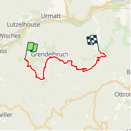

Lengte
16,9 km

Max. hoogte
770 m

Positief hoogteverschil
358 m
Km-Effort
23 km

Min. hoogte
288 m

Negatief hoogteverschil
727 m
Boucle
Neen
Datum van aanmaak :
2014-12-10 00:00:00.0
Laatste wijziging :
2014-12-10 00:00:00.0
2h43
Moeilijkheid : Gemakkelijk

Gratisgps-wandelapplicatie
 SityTrail
IGN / Geografische instituten
SityTrail Plus
De wereld gaat voor u open
Over ons
Tocht Paard van 16,9 km beschikbaar op Grand Est, Bas-Rhin, Grendelbruch. Deze tocht wordt voorgesteld door holtzv.
Plaatsbepaling
Land:
France
Regio :
Grand Est
Departement/Provincie :
Bas-Rhin
Gemeente :
Grendelbruch
Locatie:
Unknown
Vertrek:(Dec)
Vertrek:(UTM)
373692 ; 5372037 (32U) N.
Opmerkingen