


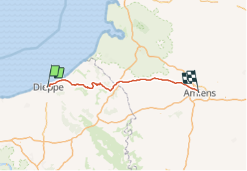
GPX retour-Dieppe-2-

ORTAX
Gebruiker

Lengte
110 km

Max. hoogte
227 m

Positief hoogteverschil
1217 m
Km-Effort
126 km

Min. hoogte
0 m

Negatief hoogteverschil
1194 m
Boucle
Neen
Datum van aanmaak :
2022-03-07 11:10:33.203
Laatste wijziging :
2022-03-07 11:10:33.203

Gratisgps-wandelapplicatie
 SityTrail
IGN / Geografische instituten
SityTrail Plus
De wereld gaat voor u open
Over ons
Tocht van 110 km beschikbaar op Normandië, Seine-Maritime, Dieppe. Deze tocht wordt voorgesteld door ORTAX.
Plaatsbepaling
Land:
France
Regio :
Normandië
Departement/Provincie :
Seine-Maritime
Gemeente :
Dieppe
Locatie:
Unknown
Vertrek:(Dec)
Vertrek:(UTM)
361979 ; 5531813 (31U) N.
Opmerkingen