Tocht Mountainbike Quarten - Flumserberge - Photo

Optez pour le retour à la nature GUIDE+
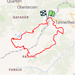
© OpenStreetMap contributors
Lengte
Lengte
16,7 km
Max. hoogte
Max. hoogte
2013 m
Positief hoogteverschil
705 m
Km-Effort
Km-Effort  
26 km
Min. hoogte
Min. hoogte
1348 m
Negatief hoogteverschil
709 m
Boucle
Boucle
Ja
Datum van aanmaak :
2014-12-10 00:00:00.0
Laatste wijziging :
2014-12-10 00:00:00.0

(0 Bericht)

Mountainbike
Mountainbike
7h55
Moeilijkheid : Onbekend

Scan deze QR-code om de tocht te openen in de SityTrail-applicatie

Gratisgps-wandelapplicatie

Logo SityTrail SityTrail

IGN / Geografische instituten

SityTrail uit de App Store downloaden SityTrail uit Google Play downloaden

Logo SityTrail SityTrail Plus

De wereld gaat voor u open

SityTrail uit de App Store downloaden SityTrail uit Google Play downloaden SityTrail op Huawei AppGallery downloaden

Over ons

Tocht Mountainbike van 16,7 km beschikbaar op Sankt Gallen, Wahlkreis Sarganserland, Quarten. Deze tocht wordt voorgesteld door My Switzerland.

Hoogteprofiel

POI's

POI Quarten - Grossee - Photo
My Switzerland
QUARTEN 
POI Quarten - Maschgenkamm - Photo
My Switzerland
QUARTEN 
POI Flums - Panüöl - Photo
My Switzerland
FLUMS 
POI Flums - Prodalp - Photo
My Switzerland
FLUMS 
POI Flums -  - Photo
My Switzerland
FLUMS 
POI Quarten - Tannenbodenalp - Photo
My Switzerland
POI Quarten - Tannenbodenalp - Photo
My Switzerland

Plaatsbepaling

Land:
Switzerland
Regio :
Sankt Gallen
Departement/Provincie :
Wahlkreis Sarganserland
Gemeente :
Quarten
Locatie:
Unknown
Vertrek:(Dec)
Vertrek:(UTM)
521251 ; 5215433 (32T) N.


Sluiten
Mijn abonnementen