


Grand Vallon :

ARPF1
Gebruiker

Lengte
15,8 km

Max. hoogte
722 m

Positief hoogteverschil
1111 m
Km-Effort
31 km

Min. hoogte
215 m

Negatief hoogteverschil
1111 m
Boucle
Ja
Datum van aanmaak :
2022-03-12 15:38:46.095
Laatste wijziging :
2022-03-12 15:40:32.198
6h56
Moeilijkheid : Zeer moeilijk

Gratisgps-wandelapplicatie
 SityTrail
IGN / Geografische instituten
SityTrail Plus
De wereld gaat voor u open
Over ons
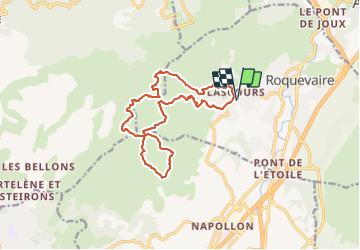
Tocht Stappen van 15,8 km beschikbaar op Provence-Alpes-Côte d'Azur, Bouches-du-Rhône, Roquevaire. Deze tocht wordt voorgesteld door ARPF1.
Plaatsbepaling
Land:
France
Regio :
Provence-Alpes-Côte d'Azur
Departement/Provincie :
Bouches-du-Rhône
Gemeente :
Roquevaire
Locatie:
Unknown
Vertrek:(Dec)
Vertrek:(UTM)
709395 ; 4802287 (31T) N.
Opmerkingen