


ortholes mn a

bouscaillou
Gebruiker
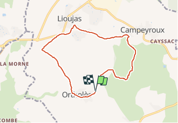

Lengte
8,3 km

Max. hoogte
644 m

Positief hoogteverschil
132 m
Km-Effort
10,1 km

Min. hoogte
561 m

Negatief hoogteverschil
130 m
Boucle
Ja
Datum van aanmaak :
2022-03-14 08:38:39.347
Laatste wijziging :
2022-03-14 10:25:59.328
1h47
Moeilijkheid : Heel gemakkelijk

Gratisgps-wandelapplicatie
 SityTrail
IGN / Geografische instituten
SityTrail Plus
De wereld gaat voor u open
Over ons
Tocht Noords wandelen van 8,3 km beschikbaar op Occitanië, Aveyron, La Loubière. Deze tocht wordt voorgesteld door bouscaillou.
Plaatsbepaling
Land:
France
Regio :
Occitanië
Departement/Provincie :
Aveyron
Gemeente :
La Loubière
Locatie:
Unknown
Vertrek:(Dec)
Vertrek:(UTM)
471276 ; 4914994 (31T) N.
Opmerkingen