


Tremblay balade a Louis

chasle
Gebruiker

Lengte
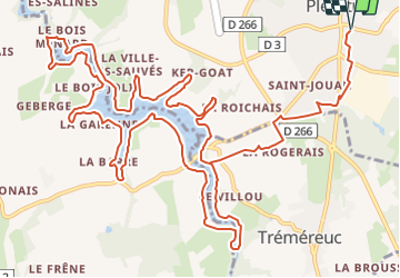
19,7 km

Max. hoogte
82 m

Positief hoogteverschil
202 m
Km-Effort
22 km

Min. hoogte
14 m

Negatief hoogteverschil
202 m
Boucle
Ja
Datum van aanmaak :
2022-03-16 16:58:32.146
Laatste wijziging :
2022-03-16 17:10:36.926

Gratisgps-wandelapplicatie
 SityTrail
IGN / Geografische instituten
SityTrail Plus
De wereld gaat voor u open
Over ons
Tocht van 19,7 km beschikbaar op Bretagne, Ille-et-Vilaine, Pleurtuit. Deze tocht wordt voorgesteld door chasle.
Plaatsbepaling
Land:
France
Regio :
Bretagne
Departement/Provincie :
Ille-et-Vilaine
Gemeente :
Pleurtuit
Locatie:
Unknown
Vertrek:(Dec)
Vertrek:(UTM)
569539 ; 5381102 (30U) N.
Opmerkingen