Tocht Stappen Eschenbach (SG) - hike21 - Photo

Optez pour le retour à la nature GUIDE+
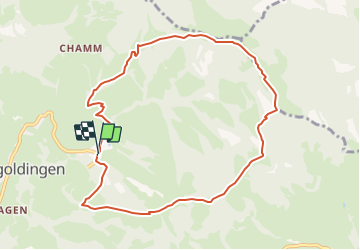
© OpenStreetMap contributors
Lengte
Lengte
9,1 km
Max. hoogte
Max. hoogte
1315 m
Positief hoogteverschil
588 m
Km-Effort
Km-Effort  
17 km
Min. hoogte
Min. hoogte
823 m
Negatief hoogteverschil
594 m
Boucle
Boucle
Ja
Datum van aanmaak :
2014-12-10 00:00:00.0
Laatste wijziging :
2014-12-10 00:00:00.0

(0 Bericht)

Stappen
Stappen
--
Moeilijkheid : Onbekend

Scan deze QR-code om de tocht te openen in de SityTrail-applicatie

Gratisgps-wandelapplicatie

Logo SityTrail SityTrail

IGN / Geografische instituten

SityTrail uit de App Store downloaden SityTrail uit Google Play downloaden

Logo SityTrail SityTrail Plus

De wereld gaat voor u open

SityTrail uit de App Store downloaden SityTrail uit Google Play downloaden SityTrail op Huawei AppGallery downloaden

Over ons

Tocht Stappen van 9,1 km beschikbaar op Sankt Gallen, Wahlkreis See-Gaster, Eschenbach (SG). Deze tocht wordt voorgesteld door My Switzerland.

Hoogteprofiel

POI's

POI Eschenbach (SG) - Schutt - Photo
My Switzerland
ESCHENBACH (SG) 
POI Eschenbach (SG) -  - Photo
My Switzerland
ESCHENBACH (SG) 
POI Eschenbach (SG) -  - Photo
My Switzerland
ESCHENBACH (SG) 
POI Eschenbach (SG) -  - Photo
My Switzerland
ESCHENBACH (SG) 
POI Wattwil -  - Photo
My Switzerland
WATTWIL 
POI Eschenbach (SG) -  - Photo
My Switzerland
ESCHENBACH (SG) 
POI Eschenbach (SG) - Schutt - Photo
My Switzerland
ESCHENBACH (SG) 

Plaatsbepaling

Land:
Switzerland
Regio :
Sankt Gallen
Departement/Provincie :
Wahlkreis See-Gaster
Gemeente :
Eschenbach (SG)
Locatie:
Unknown
Vertrek:(Dec)
Vertrek:(UTM)
499678 ; 5236780 (32T) N.


Sluiten
Mijn abonnementen