


mn 3

bouscaillou
Gebruiker
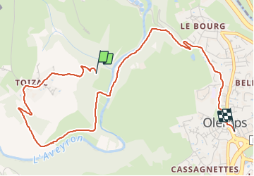

Lengte
5,5 km

Max. hoogte
611 m

Positief hoogteverschil
177 m
Km-Effort
7,7 km

Min. hoogte
507 m

Negatief hoogteverschil
127 m
Boucle
Neen
Datum van aanmaak :
2022-03-25 09:16:00.451
Laatste wijziging :
2022-03-25 10:44:24.457
1h28
Moeilijkheid : Heel gemakkelijk

Gratisgps-wandelapplicatie
 SityTrail
IGN / Geografische instituten
SityTrail Plus
De wereld gaat voor u open
Over ons
Tocht Noords wandelen van 5,5 km beschikbaar op Occitanië, Aveyron, Olemps. Deze tocht wordt voorgesteld door bouscaillou.
Plaatsbepaling
Land:
France
Regio :
Occitanië
Departement/Provincie :
Aveyron
Gemeente :
Olemps
Locatie:
Unknown
Vertrek:(Dec)
Vertrek:(UTM)
463208 ; 4910060 (31T) N.
Opmerkingen