Tocht Stappen Ferden - Ferden, Niwungrat old - Photo
 rpf
rpf

Gebruiker

© OpenStreetMap contributors
Lengte
Lengte
6,8 km
Max. hoogte
Max. hoogte
2738 m
Positief hoogteverschil
702 m
Km-Effort
Km-Effort  
16,2 km
Min. hoogte
Min. hoogte
2063 m
Negatief hoogteverschil
702 m
Boucle
Boucle
Ja
Datum van aanmaak :
2014-12-10 00:00:00.0
Laatste wijziging :
2014-12-10 00:00:00.0

(0 Bericht)

Stappen
Stappen
3h19
Moeilijkheid : Medium

Scan deze QR-code om de tocht te openen in de SityTrail-applicatie

Gratisgps-wandelapplicatie

Logo SityTrail SityTrail

IGN / Geografische instituten

SityTrail uit de App Store downloaden SityTrail uit Google Play downloaden

Logo SityTrail SityTrail Plus

De wereld gaat voor u open

SityTrail uit de App Store downloaden SityTrail uit Google Play downloaden SityTrail op Huawei AppGallery downloaden

Over ons

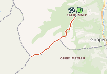
Tocht Stappen van 6,8 km beschikbaar op Valais/Wallis, Westlich Raron, Ferden. Deze tocht wordt voorgesteld door rpf.

Beschrijving

Très belle randonnée sur la crête qui relie Faldumalp au sommet du Niwen. Une boucle doit être possible en rejoignant le Faldumpass pour descendre sur l'autre côté du vallon.Départ à Faldumalp si on veut éviter la très longue et fastidieuse montée depuis le fond de la vallée, dans la forêt. La route forestière est étroite et soumise à une autorisation communale qu'on peut acheter pour Fr.10.- au parking du centre du village (automate, prévoir 2 x Fr. 5.-).
Une balade de  " www.toprando.ch "

Hoogteprofiel

Plaatsbepaling

Land:
Switzerland
Regio :
Valais/Wallis
Departement/Provincie :
Westlich Raron
Gemeente :
Ferden
Locatie:
Unknown
Vertrek:(Dec)
Vertrek:(UTM)
402972 ; 5136730 (32T) N.


Sluiten
Mijn abonnementen