


Nismes-Best of tour-9km

asblicare
Gebruiker
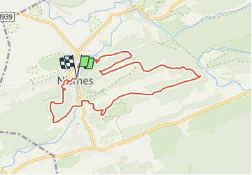

Lengte
9 km

Max. hoogte
228 m

Positief hoogteverschil
182 m
Km-Effort
11,4 km

Min. hoogte
154 m

Negatief hoogteverschil
184 m
Boucle
Ja
Datum van aanmaak :
2022-04-05 12:43:39.14
Laatste wijziging :
2022-04-05 12:45:20.157
2h35
Moeilijkheid : Gemakkelijk

Gratisgps-wandelapplicatie
 SityTrail
IGN / Geografische instituten
SityTrail Plus
De wereld gaat voor u open
Over ons
Tocht Te voet van 9 km beschikbaar op Wallonië, Namen, Viroinval. Deze tocht wordt voorgesteld door asblicare.
Beschrijving
Un tour des plus beaux coins autour de Nismes avec passage par plusieurs points de vue (Parc Nismes, Roche aux Foucons, Mousty) et par le trop connu Fondry des Chiens.
Plaatsbepaling
Land:
Belgium
Regio :
Wallonië
Departement/Provincie :
Namen
Gemeente :
Viroinval
Locatie:
Unknown
Vertrek:(Dec)
Vertrek:(UTM)
610858 ; 5548099 (31U) N.
Opmerkingen