


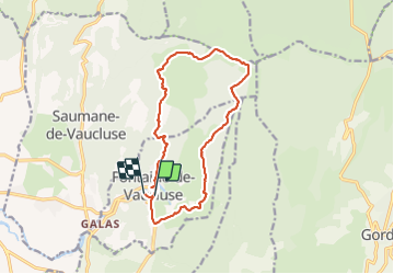
84 Fontaine de Vaucluse C1

HAL26
Gebruiker

Lengte
15,2 km

Max. hoogte
663 m

Positief hoogteverschil
655 m
Km-Effort
24 km

Min. hoogte
79 m

Negatief hoogteverschil
658 m
Boucle
Neen
Datum van aanmaak :
2022-04-06 07:19:39.735
Laatste wijziging :
2022-04-06 12:41:10.213
4h11
Moeilijkheid : Medium

Gratisgps-wandelapplicatie
 SityTrail
IGN / Geografische instituten
SityTrail Plus
De wereld gaat voor u open
Over ons
Tocht Stappen van 15,2 km beschikbaar op Provence-Alpes-Côte d'Azur, Vaucluse, Fontaine-de-Vaucluse. Deze tocht wordt voorgesteld door HAL26.
Plaatsbepaling
Land:
France
Regio :
Provence-Alpes-Côte d'Azur
Departement/Provincie :
Vaucluse
Gemeente :
Fontaine-de-Vaucluse
Locatie:
Unknown
Vertrek:(Dec)
Vertrek:(UTM)
670819 ; 4865168 (31T) N.
Opmerkingen