


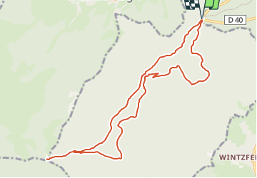
TL 04/22 Col du Firstplan - Chemin du Firstplan - Chemin du Thannhurstel - Taefelem - Col du Boenlesgrab et retour par GR 532

patrickbeyrath
Gebruiker

Lengte
10,4 km

Max. hoogte
909 m

Positief hoogteverschil
379 m
Km-Effort
15,5 km

Min. hoogte
625 m

Negatief hoogteverschil
379 m
Boucle
Ja
Datum van aanmaak :
2022-04-08 14:38:35.471
Laatste wijziging :
2022-04-09 09:11:36.305
3h45
Moeilijkheid : Medium

Gratisgps-wandelapplicatie
 SityTrail
IGN / Geografische instituten
SityTrail Plus
De wereld gaat voor u open
Over ons
Tocht Stappen van 10,4 km beschikbaar op Grand Est, Haut-Rhin, Soultzmatt. Deze tocht wordt voorgesteld door patrickbeyrath.
Plaatsbepaling
Land:
France
Regio :
Grand Est
Departement/Provincie :
Haut-Rhin
Gemeente :
Soultzmatt
Locatie:
Unknown
Vertrek:(Dec)
Vertrek:(UTM)
364617 ; 5317824 (32T) N.
Opmerkingen