


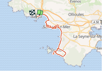
Bandol Sanary

duchaine.nicolas
Gebruiker

Lengte
37 km

Max. hoogte
91 m

Positief hoogteverschil
477 m
Km-Effort
43 km

Min. hoogte
-1 m

Negatief hoogteverschil
477 m
Boucle
Ja
Datum van aanmaak :
2022-04-10 11:56:53.446
Laatste wijziging :
2022-05-07 19:30:25.321
3h22
Moeilijkheid : Heel gemakkelijk
3h22
Moeilijkheid : Heel gemakkelijk

Gratisgps-wandelapplicatie
 SityTrail
IGN / Geografische instituten
SityTrail Plus
De wereld gaat voor u open
Over ons
Tocht Fietstoerisme van 37 km beschikbaar op Provence-Alpes-Côte d'Azur, Var, Bandol. Deze tocht wordt voorgesteld door duchaine.nicolas.
Plaatsbepaling
Land:
France
Regio :
Provence-Alpes-Côte d'Azur
Departement/Provincie :
Var
Gemeente :
Bandol
Locatie:
Unknown
Vertrek:(Dec)
Vertrek:(UTM)
723805 ; 4779109 (31T) N.
Opmerkingen