


2022-04-10_23h58m09_D1-GR10

chasle
Gebruiker
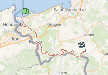

Lengte
24 km

Max. hoogte
670 m

Positief hoogteverschil
1320 m
Km-Effort
40 km

Min. hoogte
0 m

Negatief hoogteverschil
802 m
Boucle
Neen
Datum van aanmaak :
2022-04-10 21:58:09.195
Laatste wijziging :
2022-04-10 21:58:11.621

Gratisgps-wandelapplicatie
 SityTrail
IGN / Geografische instituten
SityTrail Plus
De wereld gaat voor u open
Over ons
Tocht van 24 km beschikbaar op Nieuw-Aquitanië, Pyrénées-Atlantiques, Hendaye. Deze tocht wordt voorgesteld door chasle.
Plaatsbepaling
Land:
France
Regio :
Nieuw-Aquitanië
Departement/Provincie :
Pyrénées-Atlantiques
Gemeente :
Hendaye
Locatie:
Unknown
Vertrek:(Dec)
Vertrek:(UTM)
599307 ; 4802977 (30T) N.
Opmerkingen