


sare de col en col

611686735
Gebruiker

Lengte
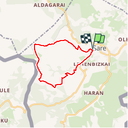
11,4 km

Max. hoogte
710 m

Positief hoogteverschil
667 m
Km-Effort
20 km

Min. hoogte
57 m

Negatief hoogteverschil
667 m
Boucle
Ja
Datum van aanmaak :
2019-02-14 12:52:20.885
Laatste wijziging :
2019-02-14 12:52:20.901
4h17
Moeilijkheid : Medium

Gratisgps-wandelapplicatie
 SityTrail
IGN / Geografische instituten
SityTrail Plus
De wereld gaat voor u open
Over ons
Tocht Stappen van 11,4 km beschikbaar op Nieuw-Aquitanië, Pyrénées-Atlantiques, Sare. Deze tocht wordt voorgesteld door 611686735.
Plaatsbepaling
Land:
France
Regio :
Nieuw-Aquitanië
Departement/Provincie :
Pyrénées-Atlantiques
Gemeente :
Sare
Locatie:
Unknown
Vertrek:(Dec)
Vertrek:(UTM)
614815 ; 4796425 (30T) N.
Opmerkingen