


L’Étang des Bésines

lebarça
Gebruiker
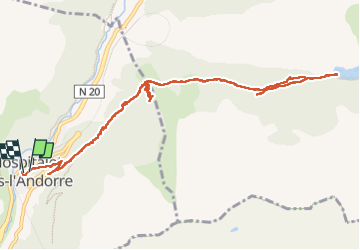

Lengte
14,2 km

Max. hoogte
1989 m

Positief hoogteverschil
692 m
Km-Effort
24 km

Min. hoogte
1434 m

Negatief hoogteverschil
715 m
Boucle
Ja
Datum van aanmaak :
2022-04-27 08:12:32.0
Laatste wijziging :
2022-04-27 14:54:20.766
6h40
Moeilijkheid : Medium

Gratisgps-wandelapplicatie
 SityTrail
IGN / Geografische instituten
SityTrail Plus
De wereld gaat voor u open
Over ons
Tocht Stappen van 14,2 km beschikbaar op Occitanië, Ariège, L'Hospitalet-près-l'Andorre. Deze tocht wordt voorgesteld door lebarça.
Plaatsbepaling
Land:
France
Regio :
Occitanië
Departement/Provincie :
Ariège
Gemeente :
L'Hospitalet-près-l'Andorre
Locatie:
Unknown
Vertrek:(Dec)
Vertrek:(UTM)
401465 ; 4715744 (31T) N.
Opmerkingen