


le vibal

bouscaillou
Gebruiker
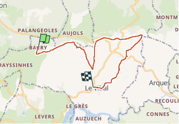

Lengte
14,6 km

Max. hoogte
930 m

Positief hoogteverschil
231 m
Km-Effort
18 km

Min. hoogte
761 m

Negatief hoogteverschil
311 m
Boucle
Neen
Datum van aanmaak :
2022-04-28 09:17:12.354
Laatste wijziging :
2022-04-28 14:08:00.945
4h50
Moeilijkheid : Moeilijk

Gratisgps-wandelapplicatie
 SityTrail
IGN / Geografische instituten
SityTrail Plus
De wereld gaat voor u open
Over ons
Tocht Stappen van 14,6 km beschikbaar op Occitanië, Aveyron, Le Vibal. Deze tocht wordt voorgesteld door bouscaillou.
Plaatsbepaling
Land:
France
Regio :
Occitanië
Departement/Provincie :
Aveyron
Gemeente :
Le Vibal
Locatie:
Unknown
Vertrek:(Dec)
Vertrek:(UTM)
477285 ; 4909011 (31T) N.
Opmerkingen