


Fozières col de la Melanque

ZITO12
Gebruiker
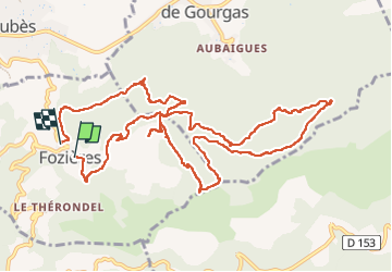

Lengte
14,3 km

Max. hoogte
674 m

Positief hoogteverschil
506 m
Km-Effort
21 km

Min. hoogte
306 m

Negatief hoogteverschil
510 m
Boucle
Neen
Datum van aanmaak :
2022-05-01 08:11:14.898
Laatste wijziging :
2022-05-01 16:26:50.509
4h11
Moeilijkheid : Medium

Gratisgps-wandelapplicatie
 SityTrail
IGN / Geografische instituten
SityTrail Plus
De wereld gaat voor u open
Over ons
Tocht Stappen van 14,3 km beschikbaar op Occitanië, Hérault, Fozières. Deze tocht wordt voorgesteld door ZITO12.
Foto's


Plaatsbepaling
Land:
France
Regio :
Occitanië
Departement/Provincie :
Hérault
Gemeente :
Fozières
Locatie:
Unknown
Vertrek:(Dec)
Vertrek:(UTM)
528789 ; 4844379 (31T) N.
Opmerkingen