


KV Sollière l'endroit

mikaelerouzic
Gebruiker
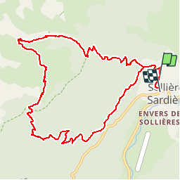

Lengte
12,1 km

Max. hoogte
2372 m

Positief hoogteverschil
1070 m
Km-Effort
26 km

Min. hoogte
1313 m

Negatief hoogteverschil
1110 m
Boucle
Neen
Datum van aanmaak :
2014-12-10 00:00:00.0
Laatste wijziging :
2014-12-10 00:00:00.0
1h30
Moeilijkheid : Zeer moeilijk

Gratisgps-wandelapplicatie
 SityTrail
IGN / Geografische instituten
SityTrail Plus
De wereld gaat voor u open
Over ons
Tocht Lopen van 12,1 km beschikbaar op Auvergne-Rhône-Alpes, Savoie, Val-Cenis. Deze tocht wordt voorgesteld door mikaelerouzic.


Plaatsbepaling
Land:
France
Regio :
Auvergne-Rhône-Alpes
Departement/Provincie :
Savoie
Gemeente :
Val-Cenis
Locatie:
Sollières-Sardières
Vertrek:(Dec)
Vertrek:(UTM)
327834 ; 5014953 (32T) N.
Opmerkingen