


2022 - Faites du SPORT - ESN Naisey les Granges

norbertmarteau
Gebruiker
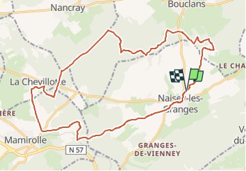

Lengte
22 km

Max. hoogte
509 m

Positief hoogteverschil
263 m
Km-Effort
25 km

Min. hoogte
422 m

Negatief hoogteverschil
265 m
Boucle
Ja
Datum van aanmaak :
2022-05-13 16:21:54.625
Laatste wijziging :
2022-05-13 16:22:45.348
1h46
Moeilijkheid : Medium

Gratisgps-wandelapplicatie
 SityTrail
IGN / Geografische instituten
SityTrail Plus
De wereld gaat voor u open
Over ons
Tocht Mountainbike van 22 km beschikbaar op Bourgondië-Franche-Comté, Doubs, Naisey-les-Granges. Deze tocht wordt voorgesteld door norbertmarteau.
Plaatsbepaling
Land:
France
Regio :
Bourgondië-Franche-Comté
Departement/Provincie :
Doubs
Gemeente :
Naisey-les-Granges
Locatie:
Unknown
Vertrek:(Dec)
Vertrek:(UTM)
291074 ; 5232886 (32T) N.
Opmerkingen