


gazon faing

jcschubnel
Gebruiker
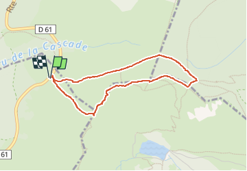

Lengte
3,5 km

Max. hoogte
1299 m

Positief hoogteverschil
119 m
Km-Effort
5,1 km

Min. hoogte
1222 m

Negatief hoogteverschil
118 m
Boucle
Ja
Datum van aanmaak :
2022-05-16 11:31:26.762
Laatste wijziging :
2022-05-17 08:37:19.505
2h12
Moeilijkheid : Gemakkelijk

Gratisgps-wandelapplicatie
 SityTrail
IGN / Geografische instituten
SityTrail Plus
De wereld gaat voor u open
Over ons
Tocht Stappen van 3,5 km beschikbaar op Grand Est, Vogezen, Le Valtin. Deze tocht wordt voorgesteld door jcschubnel.
Plaatsbepaling
Land:
France
Regio :
Grand Est
Departement/Provincie :
Vogezen
Gemeente :
Le Valtin
Locatie:
Unknown
Vertrek:(Dec)
Vertrek:(UTM)
355911 ; 5330207 (32U) N.
Opmerkingen