Tocht Mountainbike Arlebosc - 
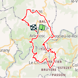
cirkwi parcours_vtt_n5 - Photo
 nisp
nisp

Gebruiker

© OpenStreetMap contributors
Lengte
Lengte
20 km
Max. hoogte
Max. hoogte
620 m
Positief hoogteverschil
672 m
Km-Effort
Km-Effort  
29 km
Min. hoogte
Min. hoogte
272 m
Negatief hoogteverschil
676 m
Boucle
Boucle
Ja
Datum van aanmaak :
2014-12-10 00:00:00.0
Laatste wijziging :
2014-12-10 00:00:00.0

(0 Bericht)

Mountainbike
Mountainbike
1h52
Moeilijkheid : Medium

Scan deze QR-code om de tocht te openen in de SityTrail-applicatie

Gratisgps-wandelapplicatie

Logo SityTrail SityTrail

IGN / Geografische instituten

SityTrail uit de App Store downloaden SityTrail uit Google Play downloaden

Logo SityTrail SityTrail Plus

De wereld gaat voor u open

SityTrail uit de App Store downloaden SityTrail uit Google Play downloaden SityTrail op Huawei AppGallery downloaden

Over ons

Tocht Mountainbike van 20 km beschikbaar op Auvergne-Rhône-Alpes, Ardèche, Arlebosc. Deze tocht wordt voorgesteld door nisp.

Hoogteprofiel

POI's

POI Arlebosc - Arlebosc - Photo
nisp
ARLEBOSC 
POI Arlebosc - Malgaray - Photo
nisp
ARLEBOSC 
POI Bozas - Saccary - Photo
nisp
BOZAS 
POI Bozas - Bozas - Photo
nisp
BOZAS 
POI Bozas - La Garenne - Photo
nisp
BOZAS 
POI Bozas - A Sapet - Photo
nisp
BOZAS 
POI Arlebosc - Grand Petit - Photo
nisp
ARLEBOSC 
POI Arlebosc - La Passerelle - Photo
nisp
ARLEBOSC 
POI Colombier-le-Jeune - Rattier - Photo
nisp
COLOMBIER-LE-JEUNE 
POI Le Crestet - Le Crestet - Photo
nisp
LE CRESTET 
POI Le Crestet - Le Banchet - Photo
nisp
LE CRESTET 
POI Arlebosc - La Planta - Photo
nisp
ARLEBOSC 

Plaatsbepaling

Land:
France
Regio :
Auvergne-Rhône-Alpes
Departement/Provincie :
Ardèche
Gemeente :
Arlebosc
Locatie:
Unknown
Vertrek:(Dec)
Vertrek:(UTM)
630146 ; 4988386 (31T) N.


Sluiten
Mijn abonnementen