


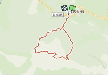
Cadiéres de Brandis par col des Léques

soca
Gebruiker

Lengte
8,3 km

Max. hoogte
1558 m

Positief hoogteverschil
426 m
Km-Effort
13,9 km

Min. hoogte
1141 m

Negatief hoogteverschil
426 m
Boucle
Ja
Datum van aanmaak :
2022-05-21 08:57:08.954
Laatste wijziging :
2022-05-21 09:07:12.798
3h55
Moeilijkheid : Moeilijk

Gratisgps-wandelapplicatie
 SityTrail
IGN / Geografische instituten
SityTrail Plus
De wereld gaat voor u open
Over ons
Tocht Stappen van 8,3 km beschikbaar op Provence-Alpes-Côte d'Azur, Alpes-de-Haute-Provence, Castellane. Deze tocht wordt voorgesteld door soca.
Plaatsbepaling
Land:
France
Regio :
Provence-Alpes-Côte d'Azur
Departement/Provincie :
Alpes-de-Haute-Provence
Gemeente :
Castellane
Locatie:
Unknown
Vertrek:(Dec)
Vertrek:(UTM)
296199 ; 4860052 (32T) N.
Opmerkingen